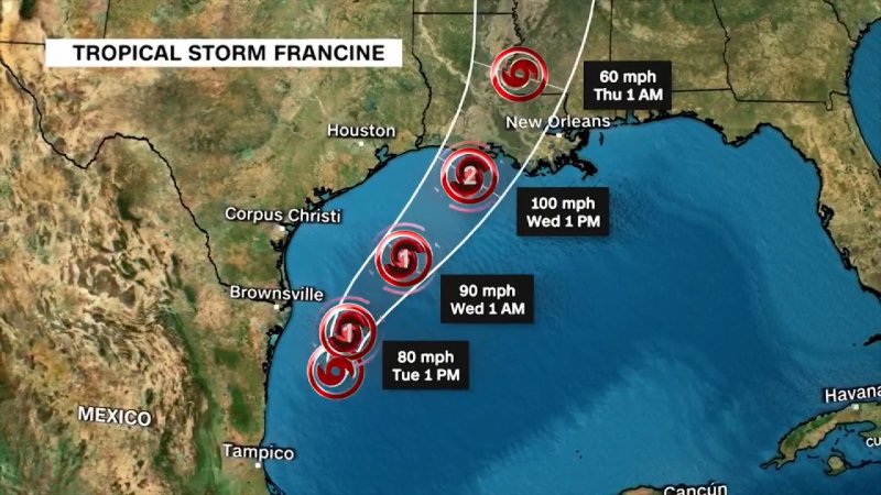
Hurricane Francine has made landfall in southern Louisiana after growing in strength into a Category 2 storm over the Gulf of Mexico.
The storm hit Terrebonne Parish at 17:00 local time (23:00GMT) on Wednesday, carrying winds of 100 mph (155 km/h), the National Hurricane Center (NHC) said.
Louisiana and neighbouring Mississippi have declared states of emergency and have told residents to take shelter and brace for the major storm.
Governor Jeff Landry said at a press briefing on Wednesday that residents should "stay off the roads, stay home and stay put".
Francine made landfall 30 miles (48km) southwest of Morgan City, which has a population of around 11,500 people.
It is forecast to bring 4-8 inches (10-20cm) of rainfall, potential tornadoes and damaging winds to much of central and eastern Louisiana, forecasters said.
More than 42,000 homes and businesses in Louisiana were already without electricity, according to Poweroutages.us.
In their latest update, the NHC said that hurricane conditions were "spreading" along the coast as the storm comes to shore.
"Now is the time to stay inside and away from windows," the NHC said.
The very wettest places could see up to 12in (30cm) of rain, bringing the risk of significant flash flooding.
Residents in eastern Louisiana, Mississippi, southern Alabama and western Florida were warned of a life-threatening storm surge.
A storm surge means there is a danger of water rising from the coastline and moving inland. In some places, water may rise up to 10ft (3m).
The hurricane is expected to cause "considerable" flash and urban flooding in parts of Louisiana, including New Orleans, the NHC warned.
All flights in and out of New Orleans airport have been cancelled for Wednesday.
Several of the state's coastal parishes are under voluntary or mandatory evacuation orders. Some schools and colleges have closed. '
US oil and gas companies on the Gulf of Mexico, including Exxon Mobil and Shell, have evacuated staff and paused some operations.