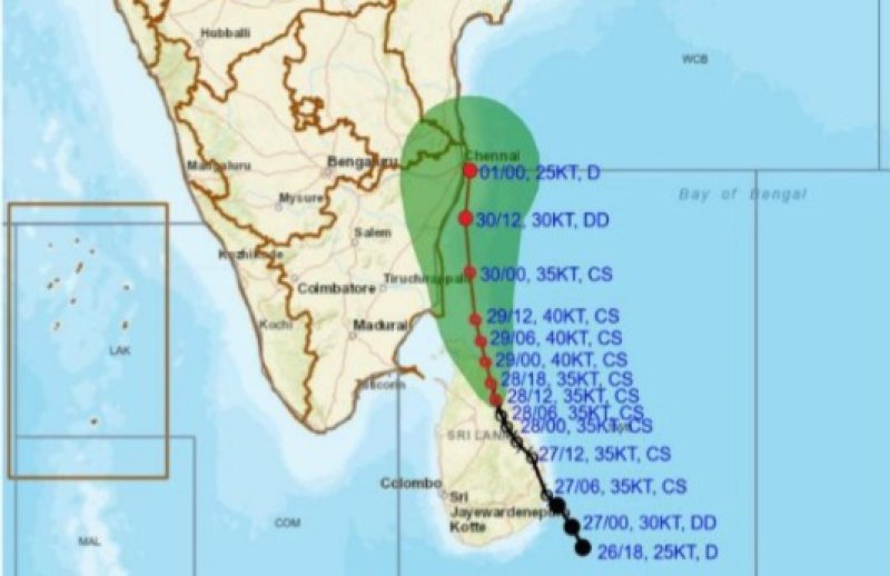
Cyclone Ditwah has moved to a position about 60 km west of Trincomalee, centered near latitude 8.8°N and longitude 80.8°E, while continuing to track north-northwestward. This system is bringing heavily overcast skies across the island, with authorities outlining its projected path and urging the public to remain alert
Continuous rain or thundershowers are expected in the Northern, North-Central, Central, North-Western Provinces and the Trincomalee District. Some locations in these regions may receive extremely heavy rainfall exceeding 200 mm.
The Sabaragamuwa and Eastern Provinces, along with the Galle and Matara districts, will experience intermittent showers or thundershowers, with rainfall possibly exceeding 150 mm in certain areas.
Strong winds of 60–70 km/h, with sudden gusts reaching 80–90 km/h, are likely across multiple parts of the island. These conditions may cause falling trees, damage to roofs, disruptions to power and communication lines, and flooding in vulnerable areas.
Residents in hilly regions, landslide-prone zones, and low-lying areas near rivers are advised to exercise extreme caution.
The Disaster Management Center has advised the public to remain indoors as much as possible, avoid using electrical appliances during thundershowers, and stay away from unstable trees and power lines.
People in high-risk zones may need to evacuate to safer locations, and drivers are urged to be vigilant in mountainous terrain.
Sea areas around the island will be severely affected, with wind speeds of 60–70 km/h and gusts up to 80–90 km/h making seas very rough. Waves may rise between 3.0–4.0 meters, with the potential for coastal inundation. Fishermen and naval vessels are strictly advised to avoid all deep and shallow sea areas until further notice.
Authorities urge the public to stay updated with further announcements from the Department of Meteorology and to follow instructions from disaster management officials as adverse weather conditions are expected to persist until November 30.