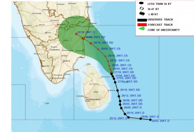
The deep depression over the southwest Bay of Bengal was located to 100 km northeast of Trincomalee at around 2.30 a.m. of 28th November 2024. It is likely to move slowly, north-northwestwards closer to the east coast of Sri Lanka and intensify further into a cyclonic storm today (28th November).
 Weather
Under influence of the system cloudy skies will prevail over most parts of the island, very heavy showers and strong gusty winds can be expected in Northern province and in Trincomalee district.
Showers or thundershowers will occur at times in Northern province and in Trincomalee district. Very heavy showers above 150 mm are likely at some places.
Showers will occur at times elsewhere of the island too. Heavy showers above 100 mm are likely at some places in North Central and North-western provinces and in and Matale and Kegalle districts.
Very strong winds of about (60-70) kmph can be expected at times over Northern, North-central, and North-western provinces and in Trincomalee district. strong winds of about (40-50) kmph can be expected at times elsewhere of the Island.
The general public is kindly requested to take adequate precautions minimize damages caused by temporary localized strong winds and lightning during thundershowers.
WEATHER FORECAST FOR SEA AREAS AROUND THE ISLAND DURING NEXT 24 HOURS
Issued at 05.30 a.m. on 28 November 2024
The deep depression over the southwest Bay of Bengal was located to 100 km northeast of Trincomalee at around 2.30 a.m. of 28th November 2024. It is likely to move slowly, north-northwestwards closer to the east coast of Sri Lanka and intensify further into a cyclonic storm today (28th November).
Naval and fishing communities are warned not to venture to the deep and shallow sea areas around the island until further notice.
Condition of Rain:
Showers or thundershowers will occur at times in the sea areas around the island.
Winds:
Winds will be north-easterly in direction in the sea areas around the island. Wind speed will be (40-50) kmph and Wind speed can increase up to (60-70) kmph at times in the sea areas around the island.
State of Sea:
The sea areas around the island will be rough to very rough at times.
The swell waves (about 2.5–3.0 m) height (this is not for land area) may increase in the sea areas off the coast extending from Batticaloa to Kankasanthurai via Trincomalee. There is a possibility that near shore sea areas off the coast extending from Batticaloa to Kankasanthurai via Trincomalee may experience surges due to swell waves.
Temporarily strong gusty winds and very rough seas can be expected during thundershowers.