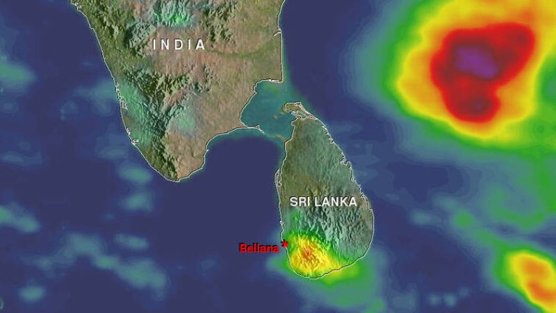
Showers or thundershowers will occur at several places in Uva and Central provinces after 02.00 p.m. Several spells of showers may occur in North-western, Western, Sabaragamuwa and Southern provinces.
Showers or thundershowers will occur at times in Northern, North-central and Eastern provinces. Fairly heavy showers above 50mm are likely at some places in Northern province.
Showers or thundershowers will occur at several places in Uva and Central provinces after 02.00 p.m.
Several spells of showers may occur in North-western, Western, Sabaragamuwa and Southern provinces.
The general public is kindly requested to take adequate precautions to minimize damages caused by temporary localized strong winds and lightning during thundershowers.
LAST 24 HOURS

Max. Temperature 32.0°C
Polonnaruwa / Monaragala

Min. Temperature 14.5°C
Nuwara Eliya

Max. Rainfall 175.4mm
Atchuvely (Jaffna)
WEATHER FORECAST FOR SEA AREAS AROUND THE ISLAND DURING NEXT 24 HOURS
Issued at 05.30 a.m. on 16 November 2023
Condition of Rain: |
Showers or thundershowers will occur at times in the sea areas off the coast extending from Mannar to Pottuvil via Kankasanthurai and Trincomalee. Showers or thundershowers will occur at a few places in the other sea areas around the Island. |
Winds: |
Winds will be South-westerly in the sea areas off the coast extending from Matara to Batticaloa via Hambantota and Pottuvil. Winds will be Northerly to North-westerly in the other sea areas around the island. Wind speed will be (20-30) kmph Wind speed can increase up to (40-50)kmph at times in the sea areas off the coast extending from Hambantota to Pottuvil and from Puttalam to Kankasanthurai via Mannar. |
State of Sea: |
The sea areas off the coast extending from Hambantota to Pottuvil and from Puttalam to Kankasanthurai via Mannar can be fairly rough at times. The other sea areas around the island will be slight to moderate. Temporarily strong gusty winds and very rough seas can be expected during thundershowers. Multi-day Boats ForecastWEATHER FORECAST FOR MULTI-DAY BOATS For the sea areas in between 20N - 10S and 60E-100E (Issued at 07.00 a.m. on 16 November 2023, for next 24hours) Sea areas around the Island Condition of Rain: Showers or thundershowers will occur at times in the sea areas off the coast extending from Mannar to Pottuvil via Kankasanthurai and Trincomalee. Showers or thundershowers will occur at a few places in the other sea areas around the Island. Winds: Winds will be South-westerly in the sea areas off the coast extending from Matara to Batticaloa via Hambantota and Pottuvil. Winds will be Northerly to North-westerly in the other sea areas around the island. Wind speed will be (20-30) kmph Wind speed can increase up to (40-50) kmph at times in the sea areas off the coast extending from Hambantota to Pottuvil and from Puttalam to Kankasanthurai via Mannar. State of Sea: The sea areas off the coast extending from Hambantota to Pottuvil and from Puttalam to Kankasanthurai via Mannar can be fairly rough at times. The other sea areas around the island will be slight to moderate. Temporarily strong gusty winds and very rough seas can be expected during thundershowers. Bay of Bengal The depression over west-central Bay of Bengal moved northwards and lay centered at 2330hrs of yesterday, the 15th November near latitude 16.0°N and longitude 86.4°E. It is likely to continue to move nearly northwards and intensify into a Deep Depression over West-central Bay of Bengal in the morning of 16th November. Thereafter, it would recurve north-northeastwards and reach Northwest Bay of Bengal on 17thmorning. Fishing and naval community are requested to be attentive to future forecasts issued by the Department of Meteorology in this regard. Weather: 10N - 20N, 85E-95E : Showers or thundershowers over most places. 05N - 10N, 80E-100E : Showers or thundershowers at several places. Other sea areas : Showers or thundershowers at a few places. Winds: 12N - 20N, 82E-93E : Anti-clockwise / (40-50) kmph, gusting up to (60-70) kmph. 05N - 12N, 90E-100E : Easterly to South-easterly / (30-40) kmph, gusting up to 50 kmph. 05N - 12N, 80E-90E : South-westerly / (20-30) kmph, gusting up to 40 kmph. EQ - 05N, 80E-90E : South-easterly / (20-30) kmph. Other sea areas : Variable / (10-20) kmph. State of the Sea: 12N - 20N, 82E-93E : Fairly rough to rough, very rough at times. 05N - 12N, 80E-100E : Moderate to fairly rough. Other sea areas : Slight to moderate. Arabian Sea Weather: EQ- 10N, 60E-80E : Showers or thundershowers at several places. Other sea areas : Showers or thundershowers at a few places. Winds: 05N-20N, 60E-75E : North-easterly to Easterly/ (20-30) kmph, gusting up to 40 kmph. EQ-02N, 60E-80E : South-easterly to Easterly/ (20-30) kmph. Other sea areas : Variable / (05-15) kmph. State of the Sea: 05N-20N, 60E-75E : Slight to moderate, fairly rough at times. Other sea areas : Slight. South Indian Ocean: Weather: EQ -05S, 60E-80E : Showers or thundershowers at several places. Other sea areas : Showers or thundershowers at a few places.
Winds: 05S -10S, 60E-100E : South-easterly to Easterly/ (30-40) kmph, gusting up to 50 kmph. Other sea areas : South-easterly / (10-20) kmph. State of the Sea: 05S -10S, 60E-100E : Moderate, fairly rough at times. Other sea areas : Slight to moderate. **Temporary strong gusty winds and rough seas can be expected during thundershowers. |